Map Info & Chart : A couple of new “township” mapping tools on Google Maps
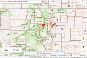
TOP IMAGE: If you want to map townships (e.g. the level between county and city in many states), they can be found on both the [City Limits on Google Maps](https://www.randymajors.com/p/citylimitsongooglemaps.html) tool and the [County Lines on Google Maps](https://www.randymajors.com/p/countygmap.html) tool *by checking the new townships box in the lower left corner of the maps*.
BOTTOM IMAGE: If you want to map Township/Range/Section, I’ve just released a new tool called [Township Range on Google Maps](https://www.randymajors.com/p/township-range-on-google-maps.html) that maps them all the way down to the quarter quarter section. You can search by address, place, GPS coordinates, or do a reverse find by Section, Township, Range using the Find tool.
Be sure and read the coverage notes and usage tips below each of the map tools.
https://i.redd.it/fluy7mtzz4431.png
By rlmcony
At infographic.tv we provide handpicked collection of the best infographics and data charts from around the world.