Map Info & Chart : New Interactive Map & Study – Deadliest Highway Stretches in California
A new interactive map study has been published of the **Deadliest Highway Stretches in California.** You can find the map and full project here:
[https://www.psblaw.com/deadliest-highway-stretches-california.html](https://www.psblaw.com/deadliest-highway-stretches-california.html)
​
[Screenshot of a section of the map](https://i.redd.it/gokdocf011n11.png)
**Here are some highlights:**
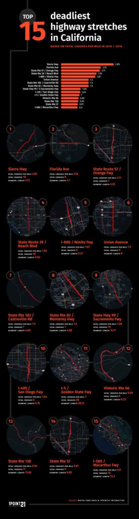
* The top 15 stretches in CA accounted for 160 fatal crashes and 172 fatalities.
* The deadliest stretch is located on Sierra Highway, located slightly east of Santa Clarita, with a whopping 2.85 fatal crashes per mile.
* Ranked #2 is on Florida Ave. (a.ka. Route 74) in Hemet, CA with a total of 8 crashes and 10 fatalities.
* 10 of the 15 deadliest stretches are located in Southern California, while only 5 are located in Northern California.
Let me know if you have any thoughts or feedback about the map study!
By Darryl1Point21
At infographic.tv we provide handpicked collection of the best infographics and data charts from around the world.