Map Info & Chart : North Circumpolar Region
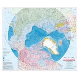
This [bilingual map](https://www.maptrove.ca/canada-maps/french/north-circumpolar-region-wall-map-bilingual-atlas-of-canada.html) shows the geography of the northern circumpolar region, north of approximately 55 degrees, at a scale of 1:9 000 000. The [map](https://www.maptrove.ca/) uses the azimuthal equidistant projection. It includes all international boundaries, as well as the Canadian provincial and territorial boundaries and Canada’s 200 nautical mile offshore exclusive economic zone. National [capital cities](https://www.maptrove.ca/canada-maps/provinces-regions/carte-du-quebec-en-francais.html) are shown, as are other cities, towns, villages and hamlets. Some seasonally populated places are also included. The map displays a number of significant northern features, including the median sea ice extent for September 1981 to 2010, the tree line, undersea relief, land relief, the Magnetic North Pole, glaciers, ice fields and coastal ice shelves. Many of the physiographic and hydrographic features are labelled.
By MapTrove
At infographic.tv we provide handpicked collection of the best infographics and data charts from around the world.